Showing posts with label John Taylor. Show all posts

Sunday, December 18, 2022

2022 IN REVIEW: PICTURES OF THE YEAR

Gaily bedlight, A gallant knight, in sunshine and in shadows had journeyed long, singing a song, in search of Eldorado --- Edgar Allan Poe


The picturesque Coloma river valley is stunning with beauty and steep in history. It was there, not far from where I slid my kayak in the churning flow of the South Fork of the American River, it all happened.
The quirky and rather odd John Marshall had a scheme about getting a sawmill going on the banks of the river for the much-needed lumber for the influx of new settlers coming to California. Financially funded by John Sutter, Marshall was constructing the mill in the Coloma Valley. By January 1848, workers had erected a building, installed the machinery and a water wheel, and dug a ditch to divert water from the river. Inspecting the work, Marshall peered down into the trail trace through a foot of water. If there would have been a camera there to record it, this is what we would have done seen.

"My eye caught a glimpse of something shining in the bottom of the ditch," Marshall gave a historical account, "I reached my hand down and picked it up; it made my heart thump, for I was certain it was gold."
 
Lake Jenkinson
And as the story goes, after he found those flakes precious metal of metal, it ushered in a wave of steely-eyed prospectors. Along with them came adventurous storytelling photographers ready to capture the historic frenzy around them. The Gold Rush was the first event in the country to be documented extensively through the then-new medium of photography.

Using daguerreotypes, an early photographic process employing an iodine-sensitized silvered plate and mercury vapor. Photographers would polish a sheet of silver-plated copper to a mirror finish, treat it with fumes that made its surface light-sensitive, and expose it in a camera for as long as it was judged to be necessary. It could be as little as a few seconds for brightly sunlit subjects or much longer for regarding the light; removed its sensitivity to light by liquid chemical treatment; rinsed and dried, and then sealed the easily marred result behind glass in a protective enclosure.

The photographers would travel about in wagons/studios, taking portraits of the miners young and old, holding the tools of their trade, a shovel, a pick, a pan. Some would even show off their precious nuggets or flakes of gold. They would show the men working as they dug away at the earth, searching for Mother Lode.

Lake Jenkinson & Sly Park Paddle Rentals

Their images were also the first to detail the environmental damage inflicted on the landscape.
Pictures show men digging away with shovels and building scaffolds in large mining operations that upheave the earth and ripped away hillsides.
The first prospectors worked their claims manually with pans and picks. But, as more arrived, the miners took to diverting entire rivers and using high-pressure jets of water to dislodge rock material or move sediment to speed up their excavations. This caused a devastating effect on the riparian natural countryside. Long after the hype for gold subsided, much of the environmental damage of this form of mining still lasts to this day.  
  
Lake Clementine & Robber's Roost
Their haunting images captured historic people and places I now call home. As I document my paddling adventures, it's a bit easier with our cell phone technology. I only hope that can create the same excitement of the Gold Rush. So as 2022 draws to a close, let's look back at some of my favorite images from this past year. 


Great American Triathlon training with Current Adventures 
  
Bayside Adventure Sports at Loon Lake

John Taylor at Sly Park 

The annual Glow Paddle on Lake Natoma
       
Salmon on the Lower American River
Kayaking with Current Adventures on Lake Natoma

The Sacramento River with Bayside Adventure Sports


Debbie Carlson at Yosemite 

Sly Park Paddle Rentals 
   
Our new home in Placerville, California

Keep up with Outside Adventure to the Max, on our Facebook page and Instagram and now on Youtube.


Friday, September 9, 2022

A WEEK IN THE SIERRA PART II


By far the greatest of all these ranges is the Sierra Nevada, a long and massive uplift lying between the arid deserts of the Great Basin and the Californian exuberance of grain-field and orchard; its eastern slope, a defiant wall of rock plunging abruptly down to the plain; the western, a long, grand sweep. Well-watered and overgrown with cool, stately forests; its crest a line of sharp, snowy peaks springing into the sky and catching the alpenglow long after the sun has set for all the rest of America. --- Clarence King

Each morning I'd peel open my tent fly and look out over the stillness of Pleasant Lake. I was at the far end of the peninsula on a flat spot, a stone's throw from a small cove less than a hundred yards wide. It was an easy swim back and forth, that I had done the day before. On the other side, a granite white and grey wall rise out of the water. The fissures and cracks in it made it look like a high-rise apartment. Its mirrored reflection in the water doubled its size. In the shadows of the morning, the wall appeared to glow.
The sun hadn't peaked over the ridge of Sierra just yet. The moon was fading into the western skies. My tent inhaled the cool dawn air as I climbed out of the tangle of my sleeping bags and put on my pullover and stocking hat.
I had the same feeling that naturalist John Muir described best on a July day in his book My First Summer in the Sierra, "Exhilarated with the mountain air, I feel like shouting this morning with excess of wild animal joy."
 
Paddling Pleasant Lake
It's a bit too early for shouting. Whispers were more in order, as I zigzagged through the brush and the hardier little Sierra Junipers trees and leaping sagebrush lizards to our Bayside Adventure Sports campsite. Where I found John Taylor already boiling a kettle of water. Nothing better to start the day than with a little pore over coffee. We've been bringing these faith-based groups from Bayside Adventure Sports for a week of outback camping to Loon Lake in the Crystal Basin Recreation Area for five years. As Muir put it so elegantly and simply, "And into the forest, I go, to lose my mind and find my soul.” Our participants always return to the flatlands, refreshed and recharged.

Paddling along the granite shore of the lake
Throughout the week, during morning and sunset paddles on the upper part of Pleasant Lake, we'd explore the narrow coves, bays, and polished granite formations. Paddling here, one can see the mountains' history, through the stories left behind in the rock.

When Padre Pedro Font named the Sierra Nevada Mountains in 1776, they had already been around for a long, long time. The ice- and snow-covered sharp saw-bladed peaks, the Spanish padre, saw had begun forming under the ocean about 100 million years ago. Beneath the surface of the earth, the granitic rocks formed from molten rock that gradually solidified. Powerful geological forces then gradually forced the landmass up under the waters of the Pacific Ocean and below an advancing North American continent. As a result, plumes of plutonic rock were pushed up towards the surface, and sheets of lava poured down the slopes of volcanic chimneys rising to the surface.
 
  
Exploring the many coves of the lake
About 50 million later, the volcanoes were extinct. The erosive agents like wind, rain, and frost ate away the softer sediments exposing the salt-and-pepper speckled Granitic rocks containing minerals including quartz, feldspars, and micas.

As the world grew colder, beginning about 2 or 3 million years ago, the Sierra Nevada mountains were coated with an extensive thick mantle of ice. It covered much of the higher altitudes and sent massive ice-crawling glaciers down its valleys. The glacial ice quarried loosed and transported vast volumes of rubble along the way, scouring and transforming the landscape that we see today.

Paddling by the polish white granite boulders, it's easy to see the evidence of the path of the last glacier. Deep grooves are carved into the rock, and erratic and huge slabs of rock are left behind and out of place in a natural balancing act. To our delight, flat smooth polished boulders at the water's edge are perfect for sunbathing and drying off on a hot day after jumping into the cool lake.
 
At sunset the mountains of the Sierra glow red 

Only the bravest trees succeed in the summit crags along the lake, despite struggling against the wind and snow. We see the Sierra junipers growing on tops and ridges and in the splits between the glacier pavements of granite. Muir called them a sturdy highlander, "Seemingly content to live for more than a score of centuries on sunshine and snow...Surely the most enduring of all the tree mountaineers, it never seems to die a natural death."
Nestled in these trees and granite walls of the Sierra are these man-made reservoirs like Loon Lake and Pleasant Lake. After years of construction, they are part of the mountain landscape. These once meadows, canyons, and riverbeds are now glimmering lakes ready to explore and make part of a new history.

On our evening trek around the lake, we were able to paddle into a picturesque pond filled with blooming water lilies protected by steep walls on all three sides. It was only because the water level was still higher than normal this time of year that we were able to see the beautiful yellow flowers in all their glory in our kayaks.
  
A hidden coves reveals blooming water lilies
We paddled back to our camp in the twilight. The sky was ablaze with brilliant golden skies and orange-tinted mountains.
Back at camp, we lay on our backs staring up at the star-filled sky just as Muir did over a century ago. "How hard to realize that every camp of men or beast has this glorious starry firmament for a roof! In such places standing alone on the mountain-top, it is easy to realize that whatever special nests we make leaves and moss-like the marmots and birds, or tents or piled stone," wrote Muir, " " We all dwell in a house of one room – the world with the firmament for its roof and are sailing the celestial spaces without leaving any track.”

At 6,378 feet, we had no trouble seeing the heavens. We were dazzled by the Starlink satellites, a moving train of bright dots traveling across the sky. Blown away by an amazing streaking meteor that burned across the sky, from horizon to horizon, and later overwhelmed by the full moon rising over the silhouetted mountain top. In my tent, I looked over the lake as moonbeams glimmered off the still water before pulling down the fly. In the distant coyotes howling at the moon, I'm sure, with pure wild animal joy.
 
A beautiful sunset ends the day on Pleasant Lake

Keep up with Outside Adventure to the Max, on our Facebook page and Instagram and now on Youtube.


Friday, May 20, 2022

HORIZON LINES

The best thing about the future is that it comes one day at a time... Abraham Lincoln

I just love to read guidebooks and look at river maps. First of all, they give you an idea of where to go. I cannot think of how many times I paged through my well-worn copy of Paddling Northern California by Charlie Pike to get an idea of where to go and where to put in. It Describes more than 65 of the best paddling trips in Northern California, including whitewater, flat water, and coastal excursions.
Just last year, a group I lead paddled the Sacramento River. A section of the river, we probably wouldn't have even thought of had it not been featured in the guide.
What to expect along the way is another reason I like to study them. As the leader of the group, I like to be a bit prepared. Warn them of possibly swift water or just give a few tidbits about the natural landmark or some history of the area. Of course, when the 80-yard portage turns into a double or triples that, I can blame it on the guidebook saying the write-up said it would be short.

The River Store
River maps showing the access, take outs, and especially the rapids are extremely important. In Duct Tape Diaries, NRS's official blog that celebrates the paddling lifestyle through compelling storytelling and photography, writer D.M. Collins gave an ode to river maps saying, "River maps are a small but mighty piece of gear. How do I know this? For one, they elicit confidence and a felt sense of security in my most anxiety-ridden river moments—at least for me. Holding and reading a map is one’s crude equivalent to central command in the backcountry. In a world riddled with screens and information at the tap of a button, the handheld binary paper map is both novel and understated in guiding one on their river journey."

Where to go and what to expect when you get there. As I start off my summer, I wish I knew. It will be out of the ordinary as my wife, Debbie, and I prepare to move to Placerville, California, a smaller Sierra Nevada foothills community located east of Sacramento. The Gold Rush-era history makes up a big part of the community's identity, but the town is also a popular destination for hiking, mountain biking, and adrenaline-pumping whitewater kayaking and rafting. Both the upper and lower sections of the South Fork American River offer rollicking rapids and gorgeous scenery. 

John Taylor and Debbie Carlson on Lake Natoma
While Working for Current Adventures Kayaking School & Trips for several years, I've logged many miles to the shop in Coloma. I'll be much closer now to my jobs at Sly Park Paddle Rentals and The River Store while a bit longer to my other employment venues. It will be a trade-off.

I'm excited about this next stage of my life as I approach this river bend. Are there worries and concerns? Of course. But as Eleanor Roosevelt said, "The future belongs to those who believe in the beauty of their dreams."

Here is a look at some of our favorite images from this year so far.


Lake Clementine 

Lake Natoma 

Lake Comanche Reservoir

Current Adventures' Dan Crandall 

Debbie Carlson & Yosemite Valley 

Lake Lodi 

Lake Clementine

Lake Jenkinson 

Rattlesnake Bar & Folsom Lake 

Keep up with Outside Adventure to the Max, on our Facebook page and Instagram and now on Youtube.

Friday, March 18, 2022

OVER THE BOW: THE CONFLUENCE OF THE AMERICAN AND SACRAMENTO RIVERS


Looking downstream on the Sacramento River, we can see the Sacramento city skyline about a mile. It gave me a slight chuckle as I said to my paddling partner John Taylor, "Those are some strange-looking mountains downriver."
John retorted back, "Your right. And there is not any snow on top of them either."

When most people in vison kayaking or canoeing, they will think of places far away with scenic mountain views and tranquil pine-lined lakes away from the hustle and bustle of downtown. But remember you don’t have to leave the city to enjoy a day out on the water. Urban paddling is something you can do in many cities. In Sacramento, California, paddling the Lower American River offers an unexpected way to get active in the outdoors while seeing the waterway destination from a new perspective.

“We are so fortunate to have this 4,800-acre, 23-mile waterway in the middle of our urban core that we can ride bikes on, we can kayak, we can horseback ride, all of these things as well as have family picnics, that we don’t want to see that go away,” Dianna Poggetto the executive director of American River Parkway Foundation, told Fox 40 during a recent a volunteer cleanup effort of the riverway.
Multiple homeless encampments along the parkway have caused a myriad of issues for civic leaders and nearby residents. Their biggest complaint is the trash and debris that's left along the banks of the river. Throughout the year, volunteers participate in the effort to accumulate the trash left behind.

It was a left turn around the high bank of Discovery Park to the Lower American River from the Sacramento River. And it was easy to tell where one ends and the other begins. The Sacramento was colored darker with suspended soil, minerals, or other deposits, making it quite murky compared to clear running American. Paddling into the river's current, the change was instantaneous.

The lower American River was designated as a "Recreational River" under both the California Wild and Scenic Rivers Act and the National Wild and Scenic Rivers Act. One of only seven rivers in California to receive this protective status, the American River offers a rich array of recreational activities, wildlife viewing, along with its colorful history.
The Nisenan Native Americans were the first people to live here along the banks for hundreds of years. They called the river Kum Sayo, which translated means "roundhouse river." Naming it after their dwelling along banks.
Explorer and trapper Jedediah Smith showed in here in 1828, upsetting the Mexican authorities and freaking the Nisenan people along the river. He dubbed it the Wild River, but the name did not last. By the time, John Sutter built his fort further upstream, the area settlers and Native Americans named the river Rio de Los Americanos or American River.

Over the Bow is a feature from Outside Adventure to the Max, telling the story behind the image. If you have a great picture with a great story, submit it to us at nickayak@gmail.com

Keep up with Outside Adventure to the Max, on our Facebook page and Instagram, and now on Youtube.


Friday, March 11, 2022

WIND & WAVES


When the winds from the North don't venture forth.


Back in the Midwest, I never really got used to the wind. It was somewhere between an icy blast from the North. It's a tornadic rage from the west or a fiery blow torch from the South. Cool breezes were rare, calm days even more. The wind always seemed to be blowing. I can still remember those white-capped Minnesota lakes pushing the boats around.
As a kayaker, the wind is always advantageous. I can tolerate snow. Paddle through the rain on any day.
But it's always those stiff gusty winds that will prove to be the most troublesome. The wind is arguably the biggest environmental factor that can turn my otherwise beautiful kayaking day into a major struggle.

The America Canoe Association, Outdoor Adventures Kayaking book, published in 2009, says that the wind, particularly in touring and sea kayaking, where the paddler is exposed to large expanses of open water is usually the biggest factor to be concerned with. The instructional resource book says, "Wind causes two problems for the kayaker. First, a wind coming from any direction, except head-on, tends to weathervane the boat, sweeping it sideways toward the destination. This not only throws the boater off course but also makes the kayak feel less stable since it is being pushed sideways across the water."
The book went on to say what every experienced paddler already knows. Headwinds can quickly tire you out and make that destination you are heading for seem to take forever to get to. While a good tailwind can be a paddler's friend as long as the winds continue to blow in the direction you are traveling.
The wind is what makes waves. The unobstructed length of water over which wind can blow is called "Wind Fetch." The strength of the wind and the time it blows over the open water will determine the height of waves. The highest energy waves will form where there is a long expanse of unblocked water and sustaining high winds. So yes, kayaking can certainly be a wonderful experience on a lake like Lake Tahoe, but with some 22 miles of "Fetch" it can also be a tiger when the afternoon winds come up pushing large waves.
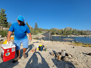
So, while the not the ocean, big lakes can have winds over 10-mph be dramatically change paddling conditions and change your relaxing experience into a Peloton workout in no time. Our Sierra foothills lakes can often be accompanied by a stiff westerly afternoon wind requiring some intermediate boating skills to take on the rough and choppy lake swells. Over the years, I've learned many of my favorite paddling lakes consistence bad habits of strong gust beginning in the late morning and continuing throughout the day but eventually dying down towards evening.

Plan your kayak routes and canoes around the expected wind patterns in your area. Mornings and evenings are best for excursions to avoid those breezy gusts of the afternoon that will make your paddling day and anyone you like to paddle with much easier.
But while nobody wants to paddle into a headwind, it can be an exhilarating exercise.

"If the waves are rolling and you are forced to make your way against them, there is the joy of battle," writes canoe guru Sigurd Olson, "Each comber an enemy to be thwarted, a problem in approach and defense."
I can share a bit of Olson's glee. But only for a little while. I prefer dodging the gust and waves and seeking protection along the calmer shore and around islands blocking the strong gusts and fighting the wind for shorter periods of short distances. At least, that is always my plan when the wind comes up.
 
 
Lake Comanche 
California's Camanche Reservoir, located east of Lodi, was named after the gold-mining town of Camanche built-in 1849, referring to the fierce southern plains' native American tribe by the same name. The town, now long gone at the bottom of the lake, is only a memory. But on breezy days, the waterway can live up to its fierce namesake when the northern winds toss whitecaps over the lake.
John Taylor and I have battled strong winds before. Both on the Sierra high Loon Lake and even on those blustery days on Lake Natoma. We've struggled to keep our group together on foothills finger Lake Clementine when the afternoon wind picked up. I have had to help a couple of tired paddlers back to the access by towing them along.
It was choppy when we started out on Lake Comanche. We headed out across the broad expanse of the lake from one of the many accesses of the Camanche Recreation Company campground and day-use area. We paddled to the east and found protection in the narrows of the lake. The high cliffs along the lake's east shores resemble a mini–Grand Canyon experience with tall multicolored rock formations on each side of us. After the narrows, we paddled into an area of grassy beaches called China Gulch, where we enjoyed wildlife views of eagles and otters.

Knowing the winds were picking up, we did not dare go further. Turning back into the wind, we knew it would be a battle to return to an even further access point where our truck was parked. When average wind speeds begin to climb into the 15 to 20 mile per hour range, that is when it’s time to get off the water. Anything above 20 miles per hour starts to become downright dangerous. We didn't know if it was blowing 10, 15, or even, 20 mph. All we knew was it was time for plan B. We needed to get off the lake as soon as possible.

Most lake paddlers start and finish at the same location. But wind can derail that plan. So, if you even have the slightest inkling that heavy winds could hamper your return, make sure you identify one or two other shoreline locations where you can land your craft if you can’t make it back to your starting location. There is no reason to tough it out, out there. Always think safety first.

I set my sights on a point on the other side of the lake. It was an island in high water, A peninsula when the lake is low. Either way, it would be our alternate landing.
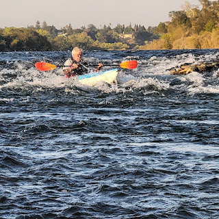
The wind and waves seemed to push us backward as we slowly paddled toward the peninsula. John in canoe trailed behind became a tiny yellow speck slipping over the tops of the whitecaps. As we all know, canoes sit a bit higher in the water and are a little more wind prone than kayaks. John was in a real battle against nature.

"The beast's claws scraped at the sky from the water below," wrote Natalie Warren in her book Hudson Bay Bound about the lashing waves of Lake Winnipeg," The large swells grew taller and sharper, threatening to crest and crash with each peak. If we swamped here, we would be trouble."

I felt the same as bounded over the waves. Using shorter and more frequent strokes into the headwind, was considerably more tiring. Paddle, paddle. Maneuvered some more big waves, and I tried to look behind me to check on John's process.
It was to my relief that I finally made it across the lake to a safely protected cove. First, I could rest. And second, I could check on John. He and his canoe had been pushed off track, but he was making steady progress across the lake. But we were not done yet.
The peninsula is connected to the mainland by a strand of hardpack mud covered with an overgrowth of weeds. My paddling guidebook said it was about 80 feet portage. It proved to be much further.

Still, it was much faster and less exhausting than paddling all the way around against the wind. After our portage, we had to paddle another short distance in the wind, before coming to our alternate landing. And it was just our luck that a friendly camping couple was there and offered us a ride to our truck.
Nobody likes to paddle into a headwind. It’s always best to have that wind to your advantage as you paddle back toward your starting location. There is satisfaction in reaching any point on the lake map despite the wind and waves. Because, at the end of the day, when the wind finally dies. Though my muscles were sore, I still reveled in my day on the water.

Keep up with Outside Adventure to the Max, on our Facebook page and Instagram, and now on Youtube.


Friday, December 24, 2021

IT'S A WONDERFUL KAYAKING LIFE

Remember, George: no man is a failure who has friends. ---It's A Wonderful Life


It never surprises me that the kayak community is much like the fictional town of Bedford Falls in Jimmy Stewart's classic Christmas movie "It's a Wonderful Life". In the movie, Stewart's character George Bailey was at the end of his rope and, all seemed lost. But at the end of the film, he wasn't thrown just one lifeline, but instead, hundreds as his family and friends from the town rallied around him by donating more than enough money to cover the missing funds and pulling him out of the depths of despair. His brother raises his glass and toasts George as "the richest man in town" while he receives a book with a note reminding him that no man is a failure who has friends.

I think we've all been there. Certainly, I have. I can't remember all the times I have been helped out by others while kayaking on the river or lake. When I forgot my paddle, need a boat? No problem, someone came through. When I needed a bit of help loading or unloading, the same thing someone came through. Once, I didn't want to be a burden to the paddling group and watched my whitewater boat float away on an untimely swim when I even turned down the help. I can handle I said. Which was not the case. It didn't matter. The paddling friend ignored my plea and helped gather my boat and gear anyway. 

Kayaker Scott Lindgren, the subject of the documentary film, “The River Runner” was released on Netflix. It takes an up-close look at Lindgren's amazing career as one of the world's most premier whitewater kayakers and his raging first descents on the epic and burly waterways of the world. In his prime, no challenge was too great, no drop was too big.
But it also gives a portrait of a paddler struggling with substance abuse and later a brain tumor that would capsize his kayaking career for ten years.
During the movie, Lindgren found that while the river gave fury, it also offered healing. Next-generation paddler Aniol Serrasolses presented him with an opportunity he had been waiting his whole life for, a run down a Himalayan river known as the Indus. It would be the final chapter in Lindgren's epic quest of running the fabled four rivers of Western Tibet's Mount Kailash.

"The fact that Aniol would consider inviting an old broken-down boater into his world blew me away," wrote Lindgren in Outside Magazine, "He was offering me something I never would have offered anyone in my condition when I was his age."

In his months of training, Lindgren wrote how the younger paddlers rallied around offering help, encouragement, and but mostly hope.
"The kids didn’t just teach me how to kayak again, they helped me open my heart," wrote Lindgren in the article.

When doctors told him the tumor had grown, Lindgren had a decision. Resume treatment or continue training. He chose kayaking. He skipped radiation, canceled his doctor appointments, and channeled his energy for the Indus run.
After what he described as a white-knuckle week through massive mountain peaks and the equally massive river, Lindgren completed his life-long dream. Realizing that, he leaned forward and put his head on the deck of his boat and wept.
And like a Christmas movie, three days after returning from the trip, he went back to the hospital for an MRI and found that his tumor had stabilized and there was no growth. The river indeed had offered healing.

Lindgren's is just one of the many paddlers helped by other paddlers. There are countless more stories out there. Many paddlers and non-profit organizations provide support and opportunities to wounded veterans and other adaptive sports programs. There are paddling groups that encourage diversification on the water. They organize welcoming paddling events for people of color to expand our paddling community that has traditionally drawn primarily white participants. And other paddlers are volunteering in thousands of river or lake cleanups across the country to remove litter and debris from our waterways. As I have said before, everyone is a friend when they have a paddle in their hand.

"Everyone recognized that we’d all have good days and bad days, and that there no shame in scaling it back when we weren’t feeling 100 percent, physically or mentally," Lindgren offered this perspective in Outside Magazine article, "The approach helped me measure my kayaking—and my life—not in wins and losses, but in whether I showed up with an open heart. If I had a bad day, I told myself it was my turn for the universe to kick my ass. If I had a good day, I enjoyed the flow of life. It was all so simple."

This Christmas, I would like to send a big thanks out to my paddling family for helping me paddle through another year. Thanks to Dan Crandall and the other superstars on Current Adventures Kayaking School and Trips, who have been there for guidance and encouragement. I look forward to returning a 2022 schedule of classes, tours, and moonlit paddles.
To the rangers and staff of Sly Park Recreation Area, thank you. I certainly hope for another successful season on shimmering Lake Jenkinson this year, with more water and no forest fires.
I lost count of my paddling events with Bayside Adventure Sports this past year. The highlights of our year included our annual Lower American River run, our camping kayaking trip to Loon Lake, and our always popular sunset and moonlit paddles on our area's lakes. Of course, none of it would have been possible without our leaders, John Taylor and Randy Kizer. Sure, I had some great ideas, but those two made it happen. I have more trips and adventures planned for the upcoming year.
My wife, Debbie, is and will always be my guiding light and inspiration. She has a deep devotion to God and love for everything living both great and small, like the starving kitten that found its way to our doorstep. I continue to strive to be like her in mind and spirit. We are both excited about being grandparents now.

And I would like to thank our faithful readers of Outside Adventure to the Max. I hope the future is now brighter for you all.

Merry Christmas

Keep up with Outside Adventure to the Max, on our Facebook page and Instagram, and now on Youtube.


Thursday, December 16, 2021

2021 IN REVIEW: PICTURES OF THE YEAR


Before we take to the sea, we walk on land ... Before we create, we must understand. --- Ernest Hemingway

 
Cruising on a Carnival Cruise through the Bahamas really isn't the type of cruise. I'm a river guy more used to trail mix, power bars, and Hydro Flask half full of water, not an endless buffet and a boat I don't have to paddle. Still, who can argue with luxury, exotic ports of calls, and an endless buffet line?

Carnival Cruise
In all of my paddling days, I've never have lost sight of land. So, it was interesting to be out on the upper deck of the giant ship looking over the bow into the vastness of the Atlantic Ocean. Clearly an overpowering feeling of aloneness. I could help to think of those intrepid paddlers that have braved these vast seas, like famed Polish adventurer Aleksander Doba against this giant ocean, alone. He made three daring voyages earned him Guinness World Records titles, and in 2017 he became the oldest person to kayak across the Atlantic. "During the entire expedition lasting 110 days and nights," said Doba in an interview, "I survived 5 storms. One of them was special. It was 8, 9, and 10 on the Beaufort scale. The waves went up to 10 m. I know that no one had survived a storm like that in such a small vessel ever before. I proved that a Pole can do it! I was happy I got to survive a storm like that, although it lasted over two days and nights, and it was not easy."

Walking along the sandy beaches of Bimini, our first port of call, was pretty cool. Bimini is the westernmost island of the Bahamas. Located about 50 miles east of Miami, Florida, it's the closest point of the Bahamas to the mainland of the United States.
It was a favorite haunt of legendary author Ernest Hemingway. An avid outdoorsman and adventurer, Hemingway lived on Bimini from 1935 to 1937. While living there, he enjoyed fishing the deep blue offshore waters for marlin, tuna, and swordfish. It was from those fishing days that inspired his classics works of The Old Man and the Sea and Islands in The Stream.
In the opening chapter of Islands in The Stream, he wrote this about Bimini, "The water of the Stream was usually a dark blue when you look out at it when there was no wind. But when you walked out into it, there was just the green light of the water over that floury white sand, and you could see the shadow of any big fish a long time before he could ever come in close to the beach."

Like Doba, Hemingway had an intense passion for daring exploits and was always in search of his next big adrenaline-fueled adventure. 
Tybee Island with KDK
And while for me, 2021 wasn't that dauntless, I did gain some new invaluable new perspectives and insights during my experiences while traveling on land, sea, rivers, and lakes.
This year, my wife Debbie and I did get to some new places. We took a trip to Cancun, Mexico, a cruise through the Bahamas to the Dominican Republic. Going coast to coast this year, we took another cruise and sailed along the Seattle skyline in Elliot Bay and took a walk along the beach with my granddaughter on Tybee Island in Georgia. In May, another big trip. On the way back from North Dakota to see family, we went cross-country. We traveled through the Black Hills of South Dakota and along the old Oregon and California trails on the way home.

While I have been living in California for almost nine years now, I still feel a bit like a tourist. There is so much to do and see in this state. I explored Slab Creek for the first time, saw a bit more of the Mokelumne River, and finally made it down the famed Gorge of the South Fork of the American River. I snowshoed through the China Wall train tunnels at Donner Pass near Truckee, California, and logged another section of the Sacramento River south of Red Bluff. 

South Fork Whitewater
I also made a return trip to Loon Lake with Bayside Adventure Sports and enjoyed some great days on the Lower American River, Lake Natoma, and Lake Clementine. The Caldor Fire cut short my season on Lake Jenkinson with Sly Park Paddle Rentals, but now as the rain and snow have now returned to California, I look forward to a fabulous summer on the lake once again next year.

My desire to travel and experience the cultures of this world only grows with age. My long list of travels to all these splendid destinations this year will have a lasting influence on me for some time to come. I will forever remember the beauty and grandeur of these places. I can only hope that my pictures have somehow captured the spirit of these whereabouts.
Hemingway wrote, "It is good to have an end to journey toward; but it is the journey that matters, in the end."
These travels have only fueled my yearnings for more adventures in years to come. And as the saying goes, as one chapter ends, another one begins. And I'll add, and the journey never ends.

Loon Lake with Bayside Adventure Sports

John Taylor at Loon Lake 

Lake Lodi

Lake Jenkinson 

Lower American River

Lake Clementine 

Lower American River

The Salt Flats of Utah 

Folsom Lake 

Glow Paddle on Lake Natoma

Slab Creek 

Keep up with Outside Adventure to the Max, on our Facebook page and Instagram, and now on Youtube.