Showing posts with label Sacramento River. Show all posts

Friday, September 30, 2022

KAYAK SUMMER 2022

It is the glistening autumnal side of summer. I feel a cool vein in the breeze, which braces my thought, and I pass with pleasure over sheltered and sunny portions of the sand where the summer's heat is undiminished, and I realize what a friend I am losing. --- Henry David Thoreau


We were lying on a white granite beach on a high Serria lakeshore staring up into the cosmos. Campfires were prohibited, and rightly so. So, the stars blazing in the sky were our only source of light since the full moon had leaped over the peaks of the mountains just yet. We were waiting for meteors to streak across the sky when someone mentioned Elan Musk's Starlink. It's a satellite internet constellation operated by SpaceX, providing satellite Internet access coverage to 40 countries around the world. Starlink now boasts well over 2,000 functional satellites orbiting overhead.

Sly Park Paddle Rentals 
Moments later, the strange moving chain of bright dots resembling a brilliant caravan of lights traveled from west to east across the sky. I tried to count the number of the bright lights but quickly lost count as they moved in succession across the sky. Lasting a few minutes, it was like a freight train rolling by and heading off to some faraway place. And then it was gone. The progression of satellites was a quick and stunning display. And then disappeared into the sky.

My summer was like that too. It's a very fast succession of days that dwindles at the dawn of autumn. Now once again, I'm saying goodbye to my well-spent summer days.

When my wife, Debbie, and I moved from Fair Oaks to Placerville, California, last May, it brought me much closer to the proximity of Sly Park and the South Fork of the American River.
Sly Park and Lake Jenkinson were a given since I was once again working the boathouse for Sly Park Paddle Rentals for my fifth year in a row. My weekends were filled with a steady dose of canoeing, kayaking, and swimming. And to think I'm lucky enough to be getting paid for it.
On the South Fork, on the other hand, I only got to cross the Highway 94 bridge. Like a lot of paddlers, I look over the bridge while driving over it to check out the current and see if I see any boats or anyone I know. And wish I was there. It didn't matter if the flow was high or low. I wanted to go. The South Fork whitewater will have to wait a while longer.

GAT training with Current Adventures 
They had been waiting for a long-time to be racing on the Lower American River. After a Covid-related shutdown for the past two summers, the Great American Triathlon race and our training resumed with Current Adventures. Dan Crandall and I showed the racers for the racers the best lines for the kayaking section run down the American River through San Juan Rapids. Win or just participate, our paddlers rocked their evening training sessions. By all reports, they rocked it on race day.

My summers wouldn't be summer without our Annual trips to Loon Lake and down the Sacramento River with Bayside Adventure Sports. Our jewel is Loon Lake on the east side of the Sierra Nevada. A scenic vista along the entire lake. It has picturesque mountain views and splendid emerald color waters surrounded by white granite boulders, laced with Sierra junipers growing on tops and ridges and in the splits between the glacier pavements of granite. My paddling partner john Taylor and I spent the whole week there leading two different groups during August. Our paddlers never know how valuable these quiet places are until they paddled into them for a few days.
 
Loon Lake with Bayside Adventure Sports

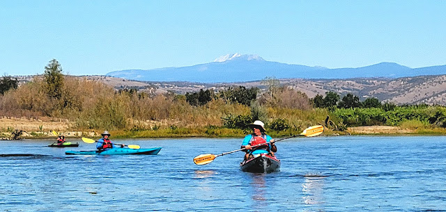
Our Sacramento River weekend trip near Red Bluff, California, finished my summer season just last weekend. The highlight was seeing Lassen Peak, one of the largest domed volcanoes in the world, as a backdrop for our fast river run.

Sandwiched in between, I paddled throughout the summer, trying to squeeze every drop out of our summer I could.
 
Lake Jenkinson & The Boathouse
"Suddenly, I experienced the feeling of longing, longing for the canyon. It was almost as if we left something back there." Recalled adventure paddler Andrzej Pietowski when describing the fleeting moments of looking back into Peru's Colca Canyon, the deepest on earth, after making its first descent down it, "Something viable, breathing, some small but living part of ourselves. The longing has remained with me ever since."
Summer 2022 is over. It's time to officially remember what day of the week it is. I do look back, longing for more of it. I feel like I left part of myself behind. I feel like I left something out.
And now, as we hurtle ourselves toward another autumn, I reflect on that high Sierra beach watching Starlink satellites trek across. Just like them, summer might be gone, but memories still flicker.

Here is a look at some of my favorite images from this past summer.


The Sacramento River with Bayside Adventure Sports 

Lake Natoma 

The Lower American River 

Shore dinner at Loon Lake 

GAT training on Lower American River 

Lake Jenkinson

The Lower American River 

Lake Jenkinson 

Keep up with Outside Adventure to the Max, on our Facebook page and Instagram and now on Youtube.


Friday, March 18, 2022

OVER THE BOW: THE CONFLUENCE OF THE AMERICAN AND SACRAMENTO RIVERS


Looking downstream on the Sacramento River, we can see the Sacramento city skyline about a mile. It gave me a slight chuckle as I said to my paddling partner John Taylor, "Those are some strange-looking mountains downriver."
John retorted back, "Your right. And there is not any snow on top of them either."

When most people in vison kayaking or canoeing, they will think of places far away with scenic mountain views and tranquil pine-lined lakes away from the hustle and bustle of downtown. But remember you don’t have to leave the city to enjoy a day out on the water. Urban paddling is something you can do in many cities. In Sacramento, California, paddling the Lower American River offers an unexpected way to get active in the outdoors while seeing the waterway destination from a new perspective.

“We are so fortunate to have this 4,800-acre, 23-mile waterway in the middle of our urban core that we can ride bikes on, we can kayak, we can horseback ride, all of these things as well as have family picnics, that we don’t want to see that go away,” Dianna Poggetto the executive director of American River Parkway Foundation, told Fox 40 during a recent a volunteer cleanup effort of the riverway.
Multiple homeless encampments along the parkway have caused a myriad of issues for civic leaders and nearby residents. Their biggest complaint is the trash and debris that's left along the banks of the river. Throughout the year, volunteers participate in the effort to accumulate the trash left behind.

It was a left turn around the high bank of Discovery Park to the Lower American River from the Sacramento River. And it was easy to tell where one ends and the other begins. The Sacramento was colored darker with suspended soil, minerals, or other deposits, making it quite murky compared to clear running American. Paddling into the river's current, the change was instantaneous.

The lower American River was designated as a "Recreational River" under both the California Wild and Scenic Rivers Act and the National Wild and Scenic Rivers Act. One of only seven rivers in California to receive this protective status, the American River offers a rich array of recreational activities, wildlife viewing, along with its colorful history.
The Nisenan Native Americans were the first people to live here along the banks for hundreds of years. They called the river Kum Sayo, which translated means "roundhouse river." Naming it after their dwelling along banks.
Explorer and trapper Jedediah Smith showed in here in 1828, upsetting the Mexican authorities and freaking the Nisenan people along the river. He dubbed it the Wild River, but the name did not last. By the time, John Sutter built his fort further upstream, the area settlers and Native Americans named the river Rio de Los Americanos or American River.

Over the Bow is a feature from Outside Adventure to the Max, telling the story behind the image. If you have a great picture with a great story, submit it to us at nickayak@gmail.com

Keep up with Outside Adventure to the Max, on our Facebook page and Instagram, and now on Youtube.


Thursday, October 14, 2021

SACRAMENTO RIVER & VIDEO

Far below, the river frothed and flowed over pebbly shallows, or broke tumultuously over boulders and cascades, in its race for the great valley they had left behind. ---Jack London

There is no better way to get away from it all than to get out on the water on a long-distance kayak trip down the upper part of the Sacramento River. The upper reaches of the river is a paddler's paradise with fast and dependable flows, changing scenery with views of Mount Shasta, Lassen Peak, and a sense of serenity while floating along on California's longest river.
Last week, while scouting out a trip for next year for the faith-based Sacramento group Bayside Adventure Sports, we paddled the 11-mile section of the river from Mill Creek Park near Los Molinos to Tahema County River Park and Woodson Bridge State Park Recreation Area about 20 miles north of Chico.

While it certainly isn't the most complicated section of the river, it does offer an ideal way for beginners to experience paddling the river. While it had a few ripples, we mostly just dodged a lot of submerged tree stags along the way. Still, the river's clear water pushed us along briskly around each bend. We weaved under only two highway bridges at the beginning and end of this semi-remote section of the river. We nodded and waved to fishermen along the way and also saw our share of turkey vultures, red-tailed hawks, and two promenade colonies of pelicans.
The put-in and the take-out were uncrowded for our October trip on the river when most recommend paddling is best, escaping the summer heat. 
"It was really nice. It was fun. It was exciting. It was everything you expect on a river trip. I can't wait to come back next year and do this with a bunch of people because it was so much fun," said Bayside Sports Paddling leader John Taylor. 


Keep up with Outside Adventure to the Max, on our Facebook page and Instagram and now on Youtube.


Friday, December 4, 2020

NEW ADVENTURES ON THE SACRAMENTO RIVER & VIDEO

"I wanted to be the first to view a country on which the eyes of a white man had never gazed and to follow the course of rivers that run through a new land." ---Jedediah Strong Smith:

In 1828, mountain man, explorer, and trailblazer Jedediah Strong Smith led an expedition up the Sacramento River through the north end of California’s Central Valley. Thinking it was the Buenaventura River, a fabled waterway once believed to run from the Rocky Mountains to the Pacific Ocean of what is now the western United States. In finding the river's true source, Smith believed he could link the east and the west with a water route by finding a waterway from coast to coast.
Of course, it didn't happen. As many explorers have found all water routes are more mythical than factual. Upon reaching a point on the river near present-day Red Bluff, California, the explorer determined it to be impassable and veered off to the northwest and the Pacific coast.

"April 10, 1828, I moved on with the intention of traveling up the Buenaventura but soon found the rocky hills coming in so close to the river as to make it impossible to travel. I went on in advance of the party and ascending a high point took a view of the county, and found the river coming from the Ne and running apparently for 20 or 30 miles through ragged rocky hills. The mountains beyond appeared too high to cross at that season of the year or perhaps at any other. Believing it impossible to travel up the river, I turned back into the valley and encamped on the river with the intention of crossing.” Jedediah Strong Smith

As a modern-day explorer, I can understand Smith's zeal for venturing into the unknown and discovering new places and remote sights. My wanderlust is always looking for different and unfamiliar rivers and lakes to explore. As J.R.R. Tolkien wrote, "Not all those who wander are lost.”
That being said, unlike Smith, the Sacramento River has been mapped, explored fished, and rafted by countless before us. Our roughly trip 25 mile trip from Anderson Riverside Park south of Redding to Bend Bridge Park north of Red Bluff is hardly the first descent. Because of its fast and lively flows, this section of the Sacramento River is extremely popular for canoeing, kayaking, and rafting. However, for everyone in our group of four paddlers, the riverway had been on a long bucket-list of one we wanted to explore.

Being California's longest river, the Sacramento offers frequent ripples, its share of standing waves and swirling whirlpools, and steady currents moving quickly in this semi-remote section of the river. Weaving southward past a few highway bridges, the river provides a cross-section of scenery along the way and able spots for camping on both sides of the river.

Likely, Smith didn't experience this section of the river. He turned off into history before exploring this section of the Sacramento River. But for the four of us, the river trip dared us for a new adventure of exploration and fresh horizon. As Astronaut Neil Armstrong said, "I think we're going to the moon because it's in the nature of the human being to face challenges. It's by the nature of his deep inner soul... we're required to do these things just as salmon swim upstream."


Keep up with Outside Adventure to the Max, on our Facebook page and Instagram and now on Youtube.

Friday, April 13, 2018

INFINITE PADDLING OPPORTUNITIES: Sacramento-San Joaquin River Delta


By Outside Adventure to the Max Guest Blogger Kathy Bunton

The Sacramento-San Joaquin River Delta, AKA the California Delta offers some exceptional paddling opportunities that are unique every time you get on the water. With a thousand miles of waterways, where do you begin? Today I'll share ideas that are within a 3-mile radius of the Antioch Marina.

Antioch Marina

Let's begin with safety. Before you head out for some time on the water there are items you need to consider before you leave the house. This is NOT a comprehensive list but a good basic starting point.
  1. Weather conditions: When paddling the San Joaquin River from Antioch, it's imperative to check wind conditions. It may be dead calm when you arrive but winds can pick up at any time and change the paddling environment drastically. Check forecasts frequently as they can change often. Use apps like Windfinder and compare with NOAA forecast. Weatherbug app has live windspeed readings from the Antioch Marina.
  2. Tides: The water flows of the Delta are tidally influenced. The river actually flows backward with an incoming tide. Plan your trip so that you will have tides in your favor for your paddle home. Do the hard work first. Wind speed and direction of water flow are very important to consider. When winds blow in a direction opposing the tide it creates a more dynamic sea state. The river can turn into ocean-like conditions with winds above 10 mph blowing against the tide.
  3. Gear: The Delta can be paddled year-round so consider dressing for immersion, in other words, dress as if you are going to swim. Fall and winter offer some of the best paddling but if you don't own a drysuit or wetsuit be sure to pack dry clothes in a dry bag to bring with you in case you do get wet. Other safety gear includes cell phone or VHF radio, whistle, snacks and water. If paddling a sea kayak make sure to bring bilge pump and paddle-float. If you are paddling a sit inside kayak with no bulkheads make sure to bring float bags to place in bow and stern of the boat. MOST IMPORTANTLY WEAR YOUR PFD - PERSONAL FLOTATION DEVICE
  4. Float Plan: Have a plan and stick to it as best as possible. The US Coast Guard has blank plans you can download as does Boat-ed. Let friends or family know where you're going and when you plan to return. File a float plan with harbormaster or leave on the dash of the vehicle.
Kimball Island
Now let's go paddling! The following are some possible trips within 3 miles of the Antioch Marina. If you like to explore or paddle at a leisurely pace I'd allow 2-3 hours for a 2-4 mile round-trip adventure; 4-8 hours for a 4-6 mile round trip paddle. I suggest using a nautical chart or topographical map to plan. There are some apps such as USTopo that allow you to track your route and websites like Routebuilder that measure distance. Bay Area Sea Kayakers have an incredible resource known as the trip planner that includes tide information. It's also a great club to join!
Paddling West:
  1. Dow Wetlands - half a mile from the marina; has lots of sloughs to explore; offers protection from wind
  2. Winter Island - approximate 1.5-mile paddle to the southern tip of Winter Island; use caution when crossing shipping channel; multiple sloughs to explore
  3. Browns Island - approximate 2.5-mile paddle to the eastern edge of the island; Middle slough can offer protection from a westerly wind; multiple sloughs to explore
  4. Broad Slough - Point San Joaquin - approximate 3.5-mile paddle; exposed to northwest winds
  5. Broad Slough - Point Sacramento - approximate 3.5-mile paddle; convergence of San Joaquin and Sacramento Rivers; tricky currents at the point
  6. Sherman Island - approximate 2-mile paddle to the entrance of Sherman Island Waterfowl Management area; hundreds of sloughs to explore; watch depth for low tides; bring GPS to keep from getting lost if exploring inside the island
  7. Kimball Island - just under a half mile across the San Joaquin River; use caution crossing shipping channel; lots of shorelines to explore
Cabin Slough
Paddling East
  1. Kimball Island - just under a half mile across the San Joaquin River; use caution crossing shipping channel; lots of shoreline to explore
  2. Cabin Slough - approximate 1-mile paddle to the entrance of Cabin Slough; currents can be strong
  3. Mayberry Cut - approximate 2-mile paddle; southern entrance to Sherman Island Waterfowl Management Area
  4. Donlon Island - approximate 2.5-mile paddle to entrance; offers protection from wind; lots of sloughs to explore
  5. West Island North -  approximate 1.5-mile paddle to north westernmost shore; some sloughs and sandy beaches exposed at low tide
  6. West Island South - approximate 1.5-mile paddle to south-westernmost shore
  7. Antioch Dunes - approximate 1.5-mile paddle; sandy cliffs; EXTREMELY SENSITIVE HABITAT DO NOT  land unless emergency
  8. Fulton Shipyard; approximate 1-mile paddle to historic shipbuilder; use caution with boat traffic from the public launch
  9. Rogers Point - just under a mile paddle; historic shipwreck Solano can be viewed here; caution with boat traffic and underwater hazards such as rebar
Sherman Island view from west shore
All the paddle trips listed above are one-way measurements, make sure to double length to get round trip distance. These are just a sampling of what is available from the Antioch Marina. There are multitudes of sloughs and channels that beg to be explored and offer a true wilderness experience next door to the city.
If you prefer someone else do the planning contact Delta Kayak Adventures to book a guided tour to the destination of your choosing. We also have kayaks and paddleboards available to rent.

Kathy Bunton is the owner and operator of Delta Kayak Adventures based in Antioch, California.  You Keep up with Bunton in her blog Kayaking in the California Delta.  

Outside Adventure to the Max is always looking for guest bloggers. Contact us at Nickayak@gmail.com, if you are interested.


Dow Wetlands
San Joaquin River

Winter Island Turkey vultures
Wind and tides can create dynamic conditions

Tuesday, March 11, 2014

On the Parkway with the Paddle Pushers


On the American River Parkway with the Sacramento Paddle Pushers.

 Most of the 23 miles of the American River Parkway meanders through the urban part of Sacramento in slow motion.  The recreation river has few ripples in places, but mostly it's a slow easy ride all the way down to the Sacramento River. Paddlers will have little trouble going against the current from confluence of the rivers up to the I-80 bridge. There are two access points for boat launching.  Tiscornia Park is just to the south of Discovery Park. It offers a small craft access underneath the Jibboom Street bridge that link the parks. Discovery Park offers one for the larger pleasure boats.  From there up stream the slow moving river offers a view several bridges to mark the progress of your trip.

 It is definitely an urban paddle. In some spots downtown skyscrapers can be seen.  Homeless camp on the banks and boats zoom by on way to a fishing spot. However, the river corridor still offers great views of birds and other wildlife. Turtles can be seen sunning themselves on logs along the river, while a number of herons nest in the trees. River otters and beaver can also be spotted along the way. This makes the parkway a great place for a weekend paddle.

 The Sacramento Paddle Pushers an online meet up group, embarked on the river this past weekend.  Over 20 some paddlers were enchanted by the river's natural surroundings and history during their outing. The group's organizer Lynn Halstead, wanted get more people out kayaking together. She began the group in October of 2010.  It now boast about 500 online members. Since, Halstead has hosted numerous paddling, biking and hiking activities. She also plans the outings months ahead in some cases.
"I just wanted to start my own group and it keep getting better." said Halstead, "It is only amazing because of all people I have come out. Just meeting all the wonderful paddlers."

 The Paddle Pushers paddle up stream from the Jibboom Street launch.  They traveled about 4 miles before stopping for a lunch break. After lunch the group returned in a relaxed fashion going down stream.


The trip on the American River Parkway.